Wednesday, October 31, 2007

Oregon's newest State Park...

...is L. L. "Stub" Stewart State Park, in the coastal range between Banks and Vernonia. They have some camping areas already done (more being developed), some cabins done, and a walk-in tent camp area. There are many trails (the bike/hike trail that connects Banks and Vernonia, the old railroad grade, goes through the park). Many of the trails on the map are not completed yet, and are closed off, and many that are open aren't signed well, but the park is just beginning and things can only get better.


We were there late Saturday afternoon last week, and here are some pics:


The trails are mostly on old logging road/skidder trails. It is beautiful forest up there! Very muddy after the rains, so we had to hike carefully and step carefully on some of the marshy trails.


This is a very hilly area, so some of the trails are not easy ones. But they (at least the ones that were opened) are all doable -- and beautiful in the fall!


Most of the flowers are already gone, but here was a big, brave lupine still blooming:


We'll definitely be visiting here again!

October colors!

After the threat of rain marathon weekend, and the real rain after, the second half of October has been beautiful. I took my camera on a run last week, just before our first frost, and admired the fall colors. The vineyards are bright yellow green, the maples are a mix of yellows and a few reds, the last of the flowers are out -- this has been a beautiful fall!


Monday, October 8, 2007

Portland Marathon 2007

Portland Marathon is my 'home' marathon. This year it was going to be a fun run -- and it was!

The start is at 7:00 in the morning - before sunrise. I picked up Sarah at her house, and we drove to Portland. There has been major road construction and blockages downtown in the last several months, so we took Naito Parkway exit, hoping to find a parking garage close to the start/finish areas (start area was also changed this year because of the construction). And amazing - somehow we turned on the right road that got us to the parking garage I usually use! :)

We spent a few minutes in the parking garage, attaching bib numbers and chips, packing the Gu and Gatorade in my water bottle holder, camera in one pocket, cell phone in the other. I chose to carry the folded poncho in my shorts pocket and left the old Tyvek jacket in the trunk. Sarah and I prayed together, then headed off to our adventure!

First stop, the porta-potty line, then to the starting area. We were going to find the 5-hour pace balloon to try to meet up with other running friends. We did meet up with Maggie, but it was so crowded, the we didn't connect with the others.

A quick picture, then a slow start. It took us about 8 minutes to reach the starting line -- chip timing is so nice!

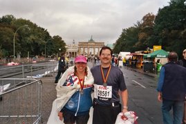
Left to right, me, Sarah, Maggie.


The Portland Marathon course runs in the downtown area for the first 5 or so miles. There are lots of musicians entertaining us on the course. Here are my favorites in the first miles:


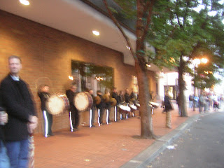
The drums are here somewhere every year near the start of the race -- very good way to set the pace to start!


The bell choir is here almost every year, too -- and we get to hear them twice, for this is where we got both directions during the early miles. Along here is where you start to see the elite runners on their come back through town.


This harpist is always at this gas station, and she plays beautiful music. I know this year it must have been hard to keep her fingers warm!


This marimba band was on the bridge that we went under on the long, gradual downhill that goes back into town.


After the downtown section, there's just over 5 miles in an out and back along the river in the industrial section. Lots of people say it's boring, but I like it. There are amazing boat docks on one side, trains on the other, and lots of people watching. This is where I saw Oksie and Larry going by. One of the bands that's along here every year is a Christian band:


After this out and back, we cross over through neighborhoods until we're down on the road leading out of town to the St. Johns Bridge. When you get your first look at the bridge, it seems like you'll never get to it!


When you do reach the bridge, only marathoners are allowed to cross. This started in 2004, when construction was going on at the bridge. They made a "Checkpoint Charlie" that runners had to pass. 2004 was the year we got to run in Berlin and see the real Checkpoint Charlie. So when Sarah and I reached this Checkpoint Charlie, we had to stop for a picture:


The St. Johns Bridge is a beautiful bridge -- and the road going up to it is steeper than the camera shows. Mile 17 is on one side, mile 18 is on the other side, and the marimba band is some happy music to hear going up the hill.


Some photos from the bridge -- the dark/light in the sky makes it look very dramatic. About 8 miles away is the finish line!


Now we're on the east side of the Willamette River, and the route winds us along the bluff overlooking the river.


This is how we look at mile 20! :) 10K to the finish!

This bluff goes on to mile 23. We met my friend, Michael, about mile 22. People in this neighborhood, whose street is shut down for hours, have many barbecues and parties. Lots of people give a cheer at about mile 12, then go back to town and cross over and find a place to cheer on this side. There are some fun musicians. There's even a yearly belly-dancing troupe, whose members I think are older than I am, plus have bigger bellies. I'm glad they are out there, but I'd rather do another kind of dance than belly dance with that physique! No, I did not take a picture of that!
A band in a driveway - and they were good!


Another view, looking towards Portland.

These two accordianists are here every year. You know, polka is a pretty good pace for a long run!

At mile 23ish is a looonnnnggg downhill section, that's not too steep for tired legs. It feels good to pick up the pace on this section. At mile 24 is the Team Red Lizard aid station. Besides the Ultima, Gleukos, and water, they offered beer.
Then comes the Steel Bridge -- mile 25 is just on the other side.


Mile 25 to mile 26 seems like the longest mile -- you get a wonderful downhill cruise off the bridge, then flat, with a down/up and a long ways to go. But you're starting to see finishers coming back looking for friends, wearing their medals and holding their mylar wraps. So you start watching for the fountain where you turn at Salmon Street, and counting off the stoplights as the blocks go by. You pass by the Saturday market -- and where the smell would ordinarily be a tasty smell, the hot grease is not something that smells good at the end of a marathon. Grab a last cup of water from the last aid station, and watch for that fountain. Say hi to John and Susan Gallagher, from Gallagher's Fitness in Salem. Say hi to Ted's family, waiting for his niece to finish. :)

Turn the corner, and it's 3 blocks to the finish line! :)

But here's a Kodak moment on the way up to 3rd Street:


Turn the last corner, and there's the finish line!


Sarah and I finished in 5:10:14 and the rain waited till we were going through the finish line (and didn't last very long then). The postrace goodies were better than usual - they had frozen fruit bars that were so good! Yep, I like the Portland Marathon!

Sightseeing on the Washington side of the Columbia Gorge


Gray Saturday afternoon before the marathon -- forecast is for wet, but so far, so good. We decided to go to Falls Creek waterfall, by way of Highway 14 on the Washington side of the river. First we stopped at North Bonneville Dam power house.

The view west, of Beacon Rock, near the front door of the Visitor's Center:


From behind the dam on the Washington side, first looking downriver, then upriver:


After we left the dam, we stopped at Bridge of the Gods overlook:


Next, we passed Skamania Lodge area, and noticed a museum that we didn't know about. We didn't go in (that'll be another trip) but walked around the outside of it. Some great cedar carvings were there, plus behind it, lots and lots of old logging equipment:

Then through Stevenson and Carson, and headed north to Falls Creek. We took the Lower Falls Creek trail. It was misting - not really rain, but occasional drops that would show up on the camera lens. The trail first cross the creek on a cable bridge:


Then the trail goes up, but not steep, for about another 1.5 miles:


The colors of fall made the dark, gray day full of bright spots. The trail is really pretty, and then you kind of curve around up a little hill and there it is:


Falls Creek falls is really big, and really beautiful. More pics:


We need to drive up there on a sunny day - just gorgeous, and hardly anyone else on the trails.